
This month’s RPG Blog Carnival topic is “Travels, by Wave, Cloud or Portal”, hosted by Seed of Worlds. I’ve been hand-waving overland travel with my current group in order to get to the important locations, and thinking about how to use point crawls to make the hand-waving less wavy. Then my group decided they would like an Underdark adventure. So much for travel, right? Well …
I decided to use Dyson Logos’ Mega Delve for the maps of a ruined dwarven mining city. The maps are incredibly detailed, which is one of the reasons I like them, but describing the maps and having the players draw their own map of where they’d been is very difficult. I ended up just showing the players each page with the complete map, which worked okay, but I felt like the sense of wonder and suspense was somewhat lost. The PCs found one of their objectives and returned to their above-ground base; I imagine they’ll come back to the dwarven mines at some point, and I’ve been thinking about better ways to represent and describe the locations.
For example, here’s one of the maps for the Mega Delve that they did not yet get to: The Thunder Mines. I added the orange lines to represent the tracks for a minecart system. The map shows some stairs down along the tracks on the bottom half of the map, and I am hoping the PCs decide to ride a minecart into this area. Careening around the bends on the ledges over the chasm will be very exciting!
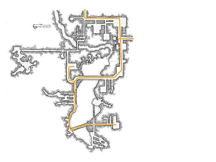
It’s a beautiful map with lots of interesting places, but this would be very hard to describe and map as it is. I came across Why I Run My Dungeons as Pointcrawls on The Pastel Dungeon blog, and thought I would try this approach to representing this section of the map.
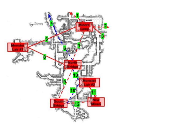
First, I labeled the major areas of interest, and the paths connecting them.

I decided on six areas, based on what I thought the PCs would explore, and made connections based on the routes included on Dyson’s map. For example, there is a set of narrow tunnels connecting the Miners’ Camp to Monster Lair #1, and wider tunnels from the Camp to the North Bridge. Neither of the connecting lines follows the paths on the map, and that’s okay with me; I decided to sacrifice the details of the map to make the connections easier to think about. Also, the red dashed lines are paths where I decided the dwarves who built the mines would have laid mine cart tracks. The solid red lines are just tunnels. The solid blue line indicates a water path, and the dashed blue lines indicates an aerial path. Lines that end in arrows connect to other areas of the Mega Delve.
In my notes, I included quick descriptions of each area. For example:
North Bridge: The minecart tracks cross a wide and deep chasm on a well-constructed stone bridge. The sound of a waterfall thunders through the area. A rickety wooden catwalk connects some small tunnels in the side of the chasm just to the north of the bridge, but there is no clear path from the bridge to the catwalk. On the opposite side of the bridge, there is another catwalk, supported by scaffolding along a ledge below the level of the bridge. There are other ledges along the chasm as it opens to the south.
Having the point crawl map overlay the original will give me a reference for the overall area, but I won’t have to worry about describing the various twists and turns and each little side path and having the PCs get bogged down in searching every single mine tunnel. The main paths, however, do need some description, so I added numbers to each path:
I wrote a quick description of each path, and what the PCs might notice from the encounter area to help them decide which way to go. For example :
Miner’s Camp: The mine cart tracks follow worked stone passages, and pass through a set of three interconnecting rooms. The rooms contain the ruined remnants of cots, footlockers, and mining tools, with the long-dead remains of many dwarven miners scattered around.
- The tracks exit the area to the north, down a worked stone tunnel that smells damp and moldy.
- The tracks exit toward the east through another worked stone tunnel.
- On the eastern side of the area is a steep stone stairway that leads up as far as you can see. Next to that is a door that opens into the bottom of a square shaft; broken stone and bits of rusted chain lie on the floor.
- The tracks also exit to the south (with a side track into the shaft). A continuous roll of thunder can be heard echoing from this corridor, and the air smells fresher.
- A narrow mine tunnel leads southwest from this area, its walls rough with chisel and pick marks. Several tunnels more cramped than the main tunnel branch off for short distances with rough, scree-filled dead-ends. (If the PCs follow this path, they come to a bridge over an underground river, flowing from the west to the east. The echoing of a waterfall comes from the east.)
Giving each path a different description that engages the senses provides the players something other than just a direction to choose from.
I will be interested to see what my players think of this way to describe where they are. None of them are avid mappers, so it should work pretty well, and I can always show them the original map once they have explored the area. An added benefit of this approach might be the ability to print out a map of each location and lay that down (or draw it quickly) to use as a battle map if needed. Getting all the details of the corridors that connect the locations is less important.
